
Saving Our Drowning Marshes: The Wetlands Institute and Its Partners Are Rising to the Challenge

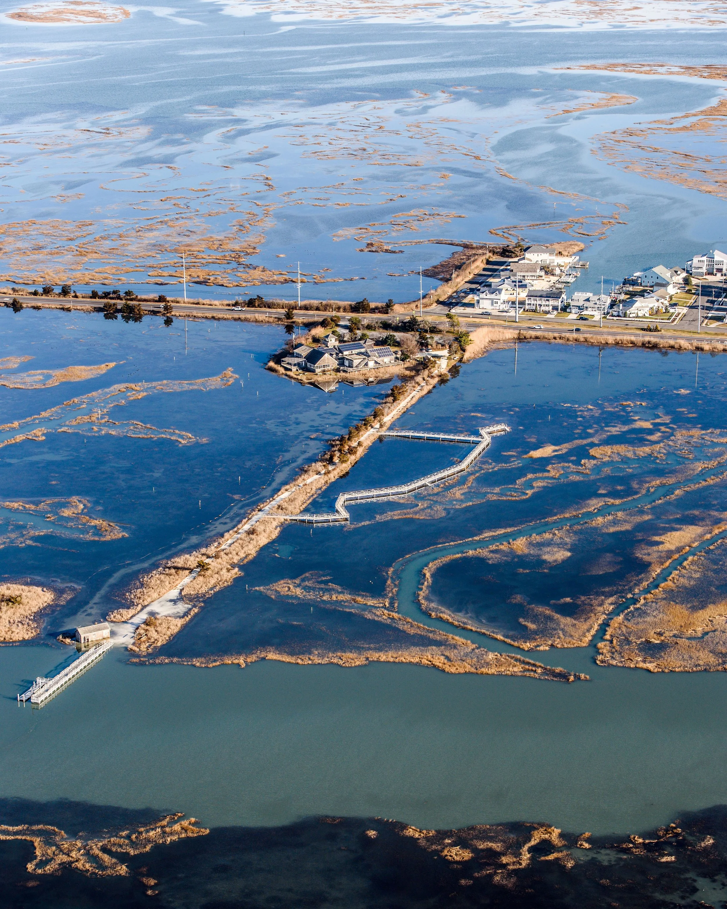
Open-water pools that have formed in the past few years are evidence of marsh loss.
By Lenore Tedesco of The Wetlands Institute
Coastal marshes, tidal creeks, and bays are the cradle of life.
They host a phenomenal diversity of wildlife that rely on them for food, nesting, and resting. They are nursery grounds for fish and shellfish. They are crucial to coastal resilience, offering protection against damage to property and infrastructure and reducing loss of life during storm surge and flooding. They are majestic, calming, and beautiful. They are part of what makes Seven Mile Beach such a special place.
Sadly, our marshes are at a tipping point and are beginning to drown. The biggest threats our wetlands, coastal ecosystems, and coastal communities face are climate change-driven rapidly rising seas. Rapidly rising seas have shifted the delicate balance between our marshes and the life-sustaining tidal waters they need. Tidal marshes flourish on the brink – daily to intermittent flooding brings life; repetitive deep flooding systematically destroys life. If you spend much time at the shore, you have seen it for yourself – our marshes are underwater at a frequency that is alarming. Local tidal marshes are inundated more frequently and to greater depths than ever before, and it’s taking a toll. This winter and spring were particularly dramatic.
The Wetlands Institute scientists, along with our colleagues from the U.S. Army Corps of Engineers, New Jersey Department of Environmental Protection (NJDEP), and five universities are diligently evaluating and monitoring these marshes to understand how rapidly rising seas are degrading them, and impacting the wildlife that depends on them. We have determined that the marshes at The Wetlands Institute are drowning and shown that what were lush meadows of unbroken grasses only a few years ago are changing to mudflats and open-water pools right before our eyes.
The projects of the Seven Mile Island Innovation Lab have been developing the tools and techniques to save drowning marshes. The project team has developed the experience and knowledge from eight projects that have already been implemented to enhance more than 85 acres of marsh so far. New Jersey is now a national leader in marsh restoration, using tools developed right here. It’s in our nature to respond – and we are!


Thankfully, along with our partners, we are again moving from evaluation to action for our marshes this fall. We are bringing a much-needed project home to the marshes at The Wetlands Institute and the adjacent Cape May Coastal Wetlands Wildlife Management Area, managed by NJDEP. Our goal is to elevate roughly 10 acres of marsh so that it has the appropriate balance with life-giving tides to ensure that the core of the institute’s laboratory and classroom, and the marshes you love to explore when you visit the institute, are healthy and vibrant for decades to come.
The project is a beneficial use of dredged material project of our partners in the Philadelphia District of the U.S. Army Corps of Engineers in partnership with NJDEP and TWI. The materials to elevate the marsh will come from maintenance dredging to improve navigation in the New Jersey Intracoastal Waterway in the vicinity of Nummy Island, west of southern Stone Harbor, under a contract awarded to Barnegat Bay Dredging Co. The material has been tested and confirmed to be free of contaminants and is a mixture of fine sand and mud that creates a favorable substrate for marsh rehabilitation. The channel dredging will use hydraulic cutter-head dredging techniques and pump the sand and mud slurry though a floating pipeline to the marshes adjacent to TWI, where it will be sprayed onto the marsh surface.
The mixture will contain a high percentage of water that will move across the marsh surface distributing the sand and mud over a wide area. We will use 100% biodegradable coconut-fiber “logs” to create partially contained areas to help settle out the sand and mud to build elevation in the most vulnerable areas of the marsh, while also directing the materials away from areas that we know are important to diamondback terrapins. The project timing in later fall is positioned at a time when there are much lower levels of wildlife usage of the marsh to help minimize short-term impacts from the project, while maximizing the long-term benefits.
We expect to place roughly 25,000 cubic yards of material on the marsh surface to elevate roughly 10 acres of marsh by about 2 feet. This equates to roughly 60 million pounds of sand equivalent or 2,500 dump truckloads of material. The project area is in an area called Scotch Bonnet Island and is just south of Stone Harbor Boulevard and just west of The Wetlands Institute. It will be visible from the institute and the boulevard. We are expecting the project to take roughly 6-8 weeks and then settle out and stabilize over the winter before to the return of wildlife in the spring.

Our experience at the other beneficial-use projects we have completed has shown that the resultant barren mud surface will cover over the marsh grasses and that it typically will take two growing seasons before we see new marsh grasses growing back over the muddy surface. We have found that planting has not been effective, nor has it accelerated the marsh recovery time, but there is plenty of marsh grass seed available for natural recruitment. For this reason, we will be letting the natural processes work their magic. There will be different usage of the marsh areas during this recovery time. For example, we have seen gulls loafing and feeding on the higher marsh surfaces created by the projects, followed by nesting attempts by some of the early adopters that include American oystercatchers. Importantly, we have seen the resultant higher marsh areas serve as vital refugia for birds of all types during storm flooding of the marsh. We know it will take a while for the marsh to regain the look of a marsh, but the added resilience that is gained by the marsh and the wildlife that depend on these marshes is well worth the wait.
A very large group of scientists and engineers have been working at Scotch Bonnet Island for the past several years to document wildlife usage and marsh structure and function. We have been diligent in planning and designing this project and have a commitment to monitoring and managing the site to ensure the best possible outcomes. This is one of the most intensely studied projects anywhere. The project will provide opportunities for natural resource managers, local municipalities, and state and federal partners to see firsthand how clean dredged materials can be used to rehabilitate drowning marshes.
Check out additional information on the project website at: wetlandsinstitute.org/scotchbonnet.com, including factsheets and a video presentation that further explains the project. Check back as the site will be continually updated with information. We will be planning tours of the project for the public as well and are excited to share the impact of the work we are doing to save drowning marshes.